How Kelvin and Meagan Get Where They're Going
Navigation
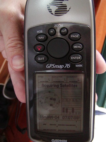 We use a hand held GPS, which stands for Global Positioning Satellite. It uses
signals from various satellites that our government has put in the sky to tell
us where we are. We can also put in location and the GPS will calculate which
direction we should sail to get where we are going! Cool, huh!
We use a hand held GPS, which stands for Global Positioning Satellite. It uses
signals from various satellites that our government has put in the sky to tell
us where we are. We can also put in location and the GPS will calculate which
direction we should sail to get where we are going! Cool, huh!
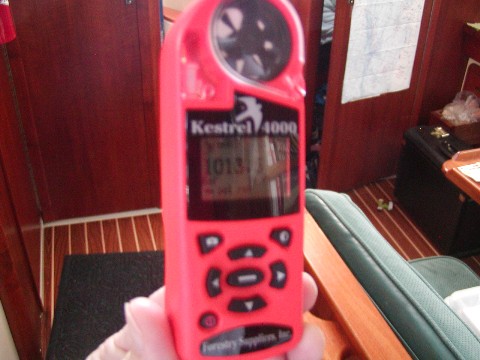 This
isn't a very good picture. Sorry. This is a KESTRAL. It is a hand held machine
that tells us many things. It tells us the temperature outside, it tells us what
the barometric pressure is when we ask it to, it can tells us how fast the wind
is going if we open up the top and let it spin in the wind. It also tells us
some very strange things that navigators need to watch like the humidity (amount
of water in the air), dew point (temperature at which condensation, or "dew"
will form on our boat) and something called "wet bulb", which I have to get a
better definition for and give you later.
This
isn't a very good picture. Sorry. This is a KESTRAL. It is a hand held machine
that tells us many things. It tells us the temperature outside, it tells us what
the barometric pressure is when we ask it to, it can tells us how fast the wind
is going if we open up the top and let it spin in the wind. It also tells us
some very strange things that navigators need to watch like the humidity (amount
of water in the air), dew point (temperature at which condensation, or "dew"
will form on our boat) and something called "wet bulb", which I have to get a
better definition for and give you later.
We don't care as much about what each of the things the Kestral
tells us as we REALLY care about CHANGES in any of these items. We take the
readings from the Kestral every hour (when we remember!) in our Passage book,
along with other readings from the boat. This keeps us thinking about sailing
and navigating all the time.
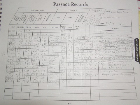 This is our passage log page in our book from our trip from Bahia Santa Maria,
Baja Mexico, to Cabo San Lucas, Baja Mexico, where we are now. Mr. Green and
Mrs. Green take "watch" 24 hours a day for 3 hour shifts. On each of our shifts
we fill in the columns at the top. When the other person takes over on their
shift, they read the notes and messages and information left by the other one
and that keeps a running "log" of what happened, and helps predict what will
happen.
This is our passage log page in our book from our trip from Bahia Santa Maria,
Baja Mexico, to Cabo San Lucas, Baja Mexico, where we are now. Mr. Green and
Mrs. Green take "watch" 24 hours a day for 3 hour shifts. On each of our shifts
we fill in the columns at the top. When the other person takes over on their
shift, they read the notes and messages and information left by the other one
and that keeps a running "log" of what happened, and helps predict what will
happen.
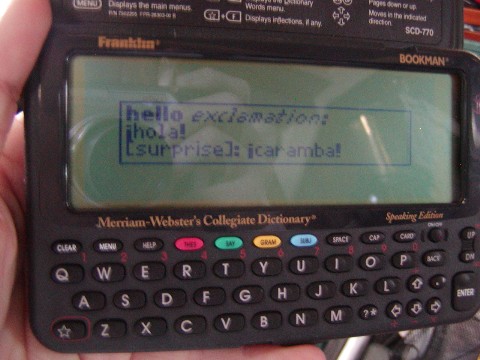 This is a very important instrument. Kelvin and Meagan were given this
dictionary by their Grandpop Green! Not only does it help them do their
homework, but you can change it to Spanish and put in an English word and it
will tell you what the word is in Spanish. And, it will speak it for you if you
want to know how to pronounce it. This is a hand held dictionary! Wouldn't that
be fun to have one in your desk right now and see what neat words come up when
you put in your English word? I think so!
This is a very important instrument. Kelvin and Meagan were given this
dictionary by their Grandpop Green! Not only does it help them do their
homework, but you can change it to Spanish and put in an English word and it
will tell you what the word is in Spanish. And, it will speak it for you if you
want to know how to pronounce it. This is a hand held dictionary! Wouldn't that
be fun to have one in your desk right now and see what neat words come up when
you put in your English word? I think so!
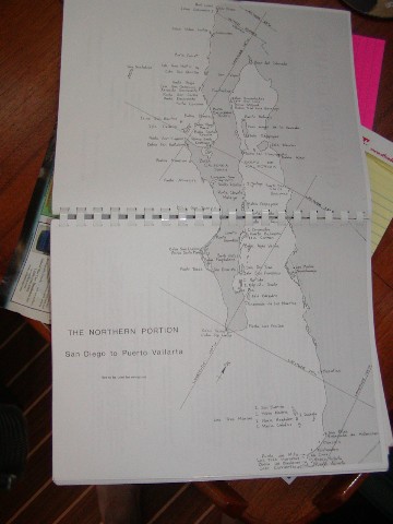 This is one
of the maps we use from a book called "Charlie's Charts". This man made a book
to help people figure out how to sail from California, where we lived, down the
coast of Mexico, which starts as the Pacific Coast of Baja California. "Baja"
means lower, so Baja California means lower California! It looks just like the
coast of California in the United States! Baja California is so far away from
the "mainland" of Mexico, which is on the right side of this map, that many
Mexican people who live here in Baja California (really part of Mexico) say they have never been to the mainland
of Mexico! They think of themselves as two different countries when you talk to
the Mexicans that live here. We will be going to the "mainland" of Mexico
tomorrow when we leave (Jan 16, 2004) for Puerto Vallarta. Do you have a map yet
to track where we are going. We are at the very tippy tippy end of that
peninsula that has the big "X" through it! To the right of the label "The Northern
Portion". We will be sailing south east towards the mainland.
This is one
of the maps we use from a book called "Charlie's Charts". This man made a book
to help people figure out how to sail from California, where we lived, down the
coast of Mexico, which starts as the Pacific Coast of Baja California. "Baja"
means lower, so Baja California means lower California! It looks just like the
coast of California in the United States! Baja California is so far away from
the "mainland" of Mexico, which is on the right side of this map, that many
Mexican people who live here in Baja California (really part of Mexico) say they have never been to the mainland
of Mexico! They think of themselves as two different countries when you talk to
the Mexicans that live here. We will be going to the "mainland" of Mexico
tomorrow when we leave (Jan 16, 2004) for Puerto Vallarta. Do you have a map yet
to track where we are going. We are at the very tippy tippy end of that
peninsula that has the big "X" through it! To the right of the label "The Northern
Portion". We will be sailing south east towards the mainland.
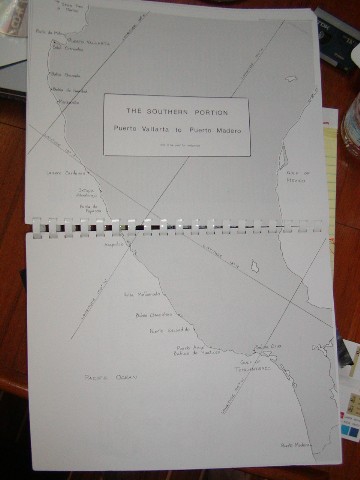 This is the Southern Portion of Mexico, showing only the mainland. It starts
where we are going next, Puerta Vallarta. I hope this helps you keep track of
where we are!
This is the Southern Portion of Mexico, showing only the mainland. It starts
where we are going next, Puerta Vallarta. I hope this helps you keep track of
where we are!
How Kelvin and
Meagan Live on a boat